Roberto Machado Noa
Disaster Zone Technology Gives Rescue Missions the Edge
Disaster zones operate on tight timelines. Minutes, or even seconds, can be the difference between life and death when people are trapped by rubble, collapsed buildings, or rising waters.
Technology has always played a part in search and rescue, and relief teams depend on a range of tools to help save lives.
Natural disasters affect around 200 million people on average each year. Between 2000 and 2019, they led to more than 1.2 million deaths. And weather–including floods, storms, and heatwaves–is the root cause of 90% of those disasters. As climate change drives more extreme weather events, technology and rescue expertise will only increase in importance.
That expertise is often provided by high-level agencies like NASA, using satellite imagery to provide ‘before and after’ maps highlighting areas damaged by the Springfield tornado. Or imagery from the 7.8 magnitude Nepal earthquake in April 2015, where an international team led by NASA helped the Nepali government identify landslide hazards, and decide where to provide relief or evacuate people.

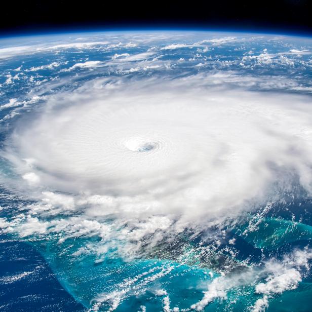
NASA/NOAA GOES Project
Severe weather system seen on NASA satellite.
Mapping work is also carried out at ground level by organizations such as MapAction, with expertise in geographic information systems and land surveying to create detailed relief and rescue maps. After the Haiti earthquake in August 2021, the charity drew up maps showing shelter, health facilities, and food distribution, but also passable roads, helicopter landing points and relief agency numbers.
One of the first actions relief agencies often take in disaster areas is to set up mobile networks so that locals and workers can communicate effectively. Local phone networks may be badly damaged or non-existent, so a mobile app developed by the Serval Project in response to the Haiti earthquake in 2010, allows phones to communicate directly with each other when networks are down.
Two-way text messaging systems can also be set up to cover a specific region, or even just one neighborhood, allowing agencies to talk to people on even the most basic mobile handsets. But communications companies can also create internet, Wi-Fi and phone networks within minutes using portable devices that can fit inside a backpack.
Small is also beautiful when it comes to finding survivors in wrecked buildings. Researchers at ETH Zurich have created a palm-sized sensor array that can detect humidity, carbon dioxide from breath, and chemicals emitted from the skin in tiny quantities. Where rescue dogs are not available, these tiny detectors could be lifesaving.
Heartbeat is another vital sign, and NASA’s FINDER is a suitcase-sized microwave technology that can identify tiny motions caused by breathing and beating hearts under tons of building debris. Following the Nepal earthquake, it helped find four men buried under 10 feet of brick, wood and mud. And in tests, FINDER has detected heartbeats through 20 feet of concrete.
In 2012, the Pentagon ran a competition to develop adaptable first responder robots capable of using human tools, including vehicles. One of the graduates of that challenge was Atlas from Boston Dynamics–a humanoid robot that can run, jump over obstacles, and do somersaults.
Atlas isn't typical of search and rescue robots. Many are much simpler tracked vehicles, like the iRobot PackBots, which helped survey and clean up Fukushima's nuclear plant after it was destroyed by the Tohoku earthquake and tsunami.
Some of the most interesting and seemingly simple designs are inspired by nature. Carnegie Mellon University's snake robot was deployed in Mexico City following an earthquake in September 2017. Snakebot was able to crawl through collapsed apartment buildings and transmit a live video feed to rescue workers, and an upgrade means that it can now swim underwater.
Others include the Cheetah 3–a rapid four-legged robot able to run at 30 miles per hour, jump over small obstacles, walk up steps and over rubble–and tiny but swift insect-like robots from MIT. Footpads allow MIT's cockroach-sized robot to move and turn quickly in tight spaces, making it ideal for rescue missions and finding hazards like gas leaks.
Drones, too, are undergoing a transformation. Unmanned aerial vehicles (UAVs) have been used for some time to detect and track wildfires, find survivors using thermal cameras, and create 3D maps to focus rescue efforts. But by pairing UAVs with algorithmic learning in a specially designed air gym, researchers hope to create autonomous drones with better navigation, able to complete complex missions on their own.
UAVs and other autonomous robots need to respond to real-world events, avoiding obstacles and making decisions. The Air Learning flight gym will help to design not only algorithms that help drones to take on specific rescue missions, but onboard computers for all kinds of autonomous robots.
But it is another natural design that could help boost the aerial drone's performance even further. MIT is working on tiny drones inspired by flying insects like the mosquito and dragonfly. Using robotic soft actuators for wing movements, made from thin rubber cylinders coated in carbon nanotubes, the drone is lightweight and sturdy enough to withstand collisions and direct hits.
These tiny drones have no motor, instead relying on electrostatic force once a current is applied that causes the wings to beat nearly 500 times a second. Scientists hope that one day they will be able to equip the drones with cameras to operate in cramped spaces and help find survivors.


